What’s The Forecast For Labor Day Weekend?
As we start towards Labor Day and the hand-off of the baton from Summer to Fall, (September 23) the forecast should (hopefully) be filled with more moderate temperatures.
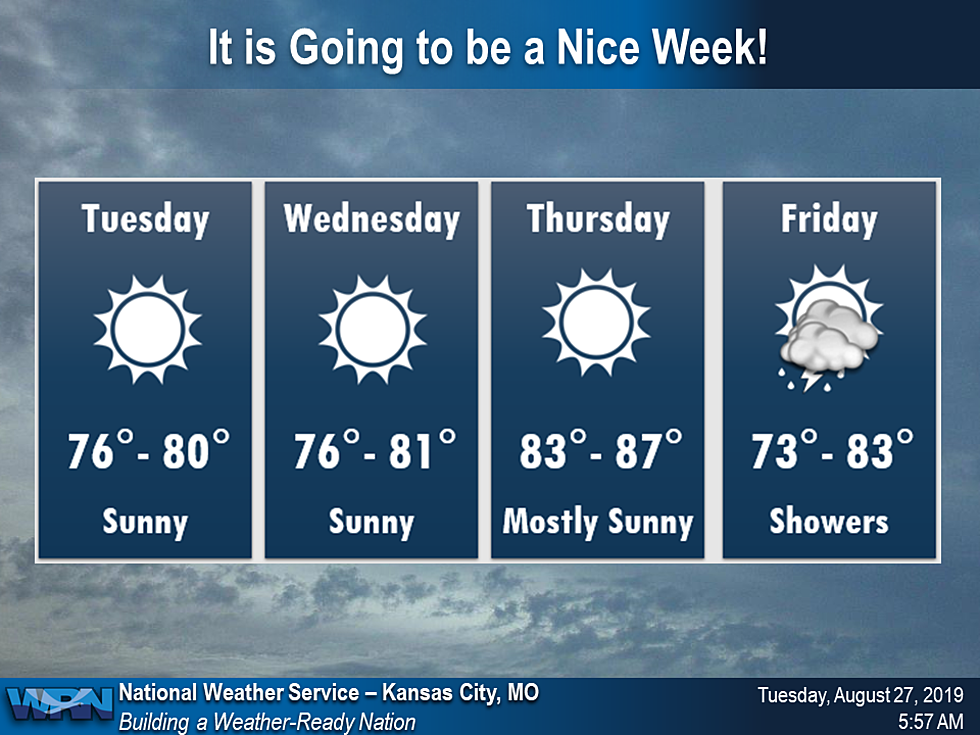
The week ahead look quite lovely for the end of August. Expect below normal temperatures Wednesday, with near normal conditions returning Thursday. However, the chance for storms will return to the region Friday and Saturday, so pay attention to the weather if your making weekend plans.
Here's the latest forecast through the three-day Labor Day weekend according to the National Weather Service:
TodaySunny, with a high near 80. South southwest wind 5 to 9 mph becoming west in the morning.TonightClear, with a low around 62. West wind around 6 mph becoming light and variable.ThursdaySunny, with a high near 85. Southwest wind 7 to 15 mph, with gusts as high as 22 mph.Thursday NightA chance of showers and thunderstorms after 2am. Increasing clouds, with a low around 66. South southwest wind 3 to 8 mph. Chance of precipitation is 30%.FridayA chance of showers and thunderstorms. Mostly cloudy, with a high near 80. Light and variable wind. Chance of precipitation is 30%. New rainfall amounts of less than a tenth of an inch, except higher amounts possible in thunderstorms.Friday NightA chance of showers and thunderstorms, mainly after 2am. Mostly cloudy, with a low around 65. Chance of precipitation is 30%. New rainfall amounts of less than a tenth of an inch, except higher amounts possible in thunderstorms.SaturdayA chance of showers and thunderstorms. Mostly cloudy, with a high near 78. Chance of precipitation is 40%.Saturday NightA chance of showers and thunderstorms before 2am. Mostly cloudy, with a low around 64. Chance of precipitation is 40%.SundayMostly sunny, with a high near 79.Sunday NightPartly cloudy, with a low around 65.Labor DaySunny, with a high near 82.

More From AM 1050 KSIS