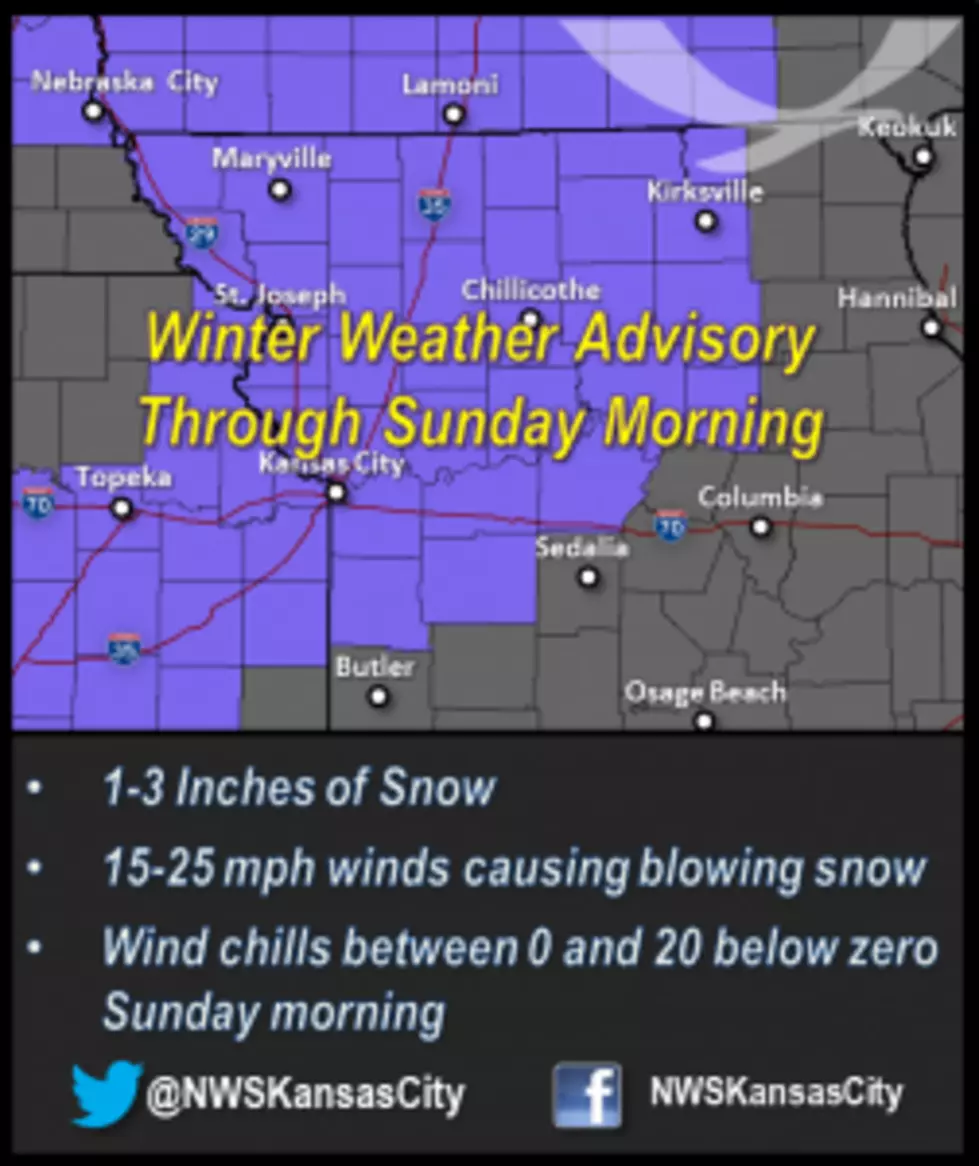
Winter Weather Advisory Through Sunday For Portions of Missouri
The snow projected for Missouri seems to be staying from the Kansas City Metro area and on up into St. Joseph and the Kirksville area. A Winter Weather Advisory has been issued for a vast majority of the northern portions of Missouri to also include, Johnson, Lafayette and Saline Counties in our area until Sunday morning.
The National Weather Service issued this advisory: ...A WINTRY MIX THIS MORNING FOLLOWED BY SNOW TONIGHT...
.A WINTER STORM SYSTEM WILL LIFT NORTHEAST THROUGH KANSAS AND
MISSOURI OVER THE NEXT 24 HOURS...GENERATING AREAS OF LIGHT RAIN...
FREEZING DRIZZLE... AND PERHAPS A LITTLE SLEET THROUGH MID
MORNING. A LULL IN THE WEATHER IS EXPECTED FROM LATE MORNING THROUGH
MID AFTERNOON AS THE BULK OF PRECIPITATION EXITS...THEN A BAND OF
RAIN TRANSITIONING TO SNOW WILL SPREAD QUICKLY FROM WEST TO EAST
THROUGH THE REGION THIS EVENING AND TONIGHT. A LIGHT GLAZE OF ICE IS
POSSIBLE IN AREAS THAT REMAIN BELOW FREEZING THIS MORNING...AND A
WIDESPREAD 1 TO 2 INCHES OF SNOW IS EXPECTED THIS EVENING AND TONIGHT.AREAS OF BLOWING SNOW ARE ALSO EXPECTED ACROSS NORTHERN MISSOURI AND
FAR NORTHEAST KANSAS TONIGHT AS BRISK NORTHWEST WINDS SURGE INTO THE
REGION AFTER 10 PM.
David Clippert, the Sedalia/Pettis County EMA Director, also passed along this advisory:
The forecast is still on track for some light snow overnight on Saturday night. Expect around 1 to 3 inches across most of the area, with perhaps localized high...er amounts, up to 4 inches.
Brisk winds will cause blowing snow conditions, limiting visibilities.
Wind chill values on Sunday morning will range from 0 degrees to nearly 20 degrees below zero.
A winter weather advisory is in effect for NE Kansas and all of NW Missouri through Sunday morning.
The Pettis County Sheriff's Office also advises that you be careful.
A Winter Weather Advisory has been issued until midnight for the counties immediately north and west of Pettis. By late afternoon, a round of winter weather will quickly spread into west central Missouri, and flash freezing conditions are likely to make already wet roadways extremely hazardous for driving.
Rain will initially spread quickly over the area, then change over to wet snow. A general 1 to 2 inches of snow is expected this evening, with the snow tapering by early Sunday morning. The expected snowfall is likely to create some travel difficulties, especially on less traveled roadways.
Gusty northwest winds tonight and Sunday will send temperatures into the lower teens, resulting in wind chill readings to around 10 below zero.
One more item to be made aware of is for the possibility of "black ice" formation later this evening. A rapid drop in temperatures is expected this evening as frigid air invades the region. This flash freeze could easily result in black ice forming on any roadways that remain wet from this evening's snowfall. Should this occur, very dangerous driving conditions will result.
The Pettis County Sheriff's Office urges you to remain alert to rapidly changing weather conditions, and use extreme caution while driving.
Please travel safely if you're going into the Kansas City Metro or northern Missouri today or tomorrow. I hope you continue to listen and look for Weathereye updates.
More From AM 1050 KSIS