Strong to severe storms are possible throughout the day, but the best chance is tonight. Hail will be the primary threat, but damaging winds are also a possibility.
Light rain ending this morning. An active pattern will commence on Wednesday, with periods of heavy rain and perhaps some scattered strong to severe thunderstorms Wednesday evening.
A nice early spring-like day today with a cool start in the 40s and 60s by the afternoon. . Widespread rain will return to the area Thursday afternoon into Friday morning, but will clear out for a nice afternoon on Friday and into the weekend.
A few rounds of showers and thunderstorms will be possible today. The round of thunderstorms this afternoon will have the potential to produce a few strong storms capable of gusty winds and small hail across portions of east central Kansas and west central Missouri. Highs today will be in the mid 60's.
The good news...the snow stayed to the north of our area. The better news? The extended forecast calls for near normal temperatures and slight favoring of above normal precipitation expected towards the end of April.
Moderate to heavy snowfall is expected to move in this afternoon and continue into the evening hours across northern Missouri and southern Iowa. Further south, rain will dominate the afternoon and much of the overnight hours before transitioning over to light snow early Friday before the system departs.
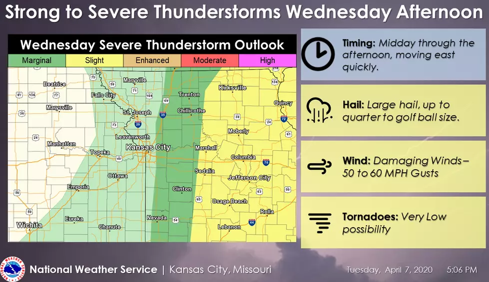
Strong to severe thunderstorms are expected across portions of Missouri Wednesday Afternoon. Storms are expected to quickly move to the east through the late afternoon and evening, with damaging hail being the primary concern.